
Vaizdas:Polish-Lithuania map (1450-1600).svg

Rinkmenos SVG peržiūros PNG dydisː 458 × 599 taškų. Kitos 6 rezoliucijos: 183 × 240 taškų | 367 × 480 taškų | 587 × 768 taškų | 782 × 1 024 taškų | 1 565 × 2 048 taškų | 726 × 950 taškų.
Didesnės raiškos iliustracija (SVG rinkmena, formaliai 726 × 950 taškų, rinkmenos dydis: 72 KiB)
| Ši byla yra iš bendros Wikimedia Commons nemokamų resursų duomenų bazės, palaikomos Wikimedia Foundation organizacijos. Norėdami sužinoti licencijavimo smulkmenas, žiūrėkite paveikslėlio aprašymą | .svg?uselang=lt) |
Į paveikslėlio aprašymą |
.svg)
.svg?uselang=lt)
Aprašymas
| Aprašymas |
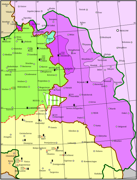
English: Map showing the conflicts and territory of the union (later commonwealth) of Poland-Lithuania.
National border
Administrative or temporal division
The Grand Duchy of Lithuania in 1450
Livonia
Other rule
Russia before 1494
Significant battles fought by Poland-Lithuania. Red: against the Tartars; Black: against Russia. Year given in small type.
Significant fortress |
| Data | |
| Šaltinis | Mano darbas |
| Autorius | Grandiose, adapted considerably from: (2001) Lietuvos istorijos atlasas, Vilnius: Vaga, pp. 16-17 ISBN 5-415-01577-9 |
| File | Type | Details |
|---|---|---|
| File:Polish-Lithuania map (1450-1600).svg | Large SVG | Map showing conflicts and territorial changes on the Polish-Lithuanian—Russian border, 1450–1600 |
| File:Duchy of Prussia.svg | Small SVG | Map of the Duchy of Prussia |
| File:Livonian war map (1558-1560).svg | Small SVG | Map showing campaigns in Livonia, 1558–1560. |
| File:Map of Poland and Lithuania after the Union of Lublin (1569).svg | Large SVG | Map of the w:Polish-Lithuanian Commonwealth after the Union of Lublin in 1569. |
| File:Livonian war map (1570-1577).svg | Small SVG | Map showing areas of Russian and Polish-Lithuanian forces, 1570–1577. |
| File:Campaigns of Stefan Batory.svg | Small SVG | Map of the campaign of Stefan Batory in Livonia (1575–1580). |
| File:Map of Poland and Lithuania in 1600.svg | Small SVG | Map of Livonia in 1600 |
| See also: User:Halibutt/maps, by Halibutt (aptarimas · indėlis). | ||
.svg)
.svg)
.svg)
Licencija
Aš, šio darbo autoriaus teisių savininkas, publikuoju jį su šia licencija:
Šiam failui taikoma Creative Commons Attribution-Share Alike 3.0 Unported licencija.
- Jūs galite:
- dalintis – kopijuoti, platinti bei persiųsti šį darbą
- pri(si)taikyti – adaptuoti darbą
- Su šiomis sąlygomis:
- autoriaus nurodymas – Turite pateikti atitinkamą kreditą, pateikti nuorodą į licenciją ir nurodyti, ar buvo atlikti pakeitimai. Tai galite padaryti bet kokiu būdu, bet ne taip, kad licencijos išdavėjas patvirtintų jus ar jūsų naudojimą.
- dalinkis panašiai – Jei perdirbsite, redaguosite ar atkursite šį darbą, jį galėsite platinti tik su tokia pačia ar panašia į šią licencija.
Rinkmenos istorija
Paspauskite ant datos/laiko, kad pamatytumėte rinkmeną tokią, kokia ji buvo tuo metu.
| Data/Laikas | Miniatiūra | Matmenys | Naudotojas | Paaiškinimas | |
|---|---|---|---|---|---|
| dabartinis | 21:02, 24 balandžio 2011 | | 726 × 950 (72 KiB) | Grandiose | Optimise |
| 21:42, 18 balandžio 2011 |  | 726 × 950 (1,5 MiB) | Grandiose | Longitude and latitude lines. | |
| 17:27, 18 balandžio 2011 |  | 726 × 950 (233 KiB) | Grandiose | Border change | |
| 16:45, 18 balandžio 2011 |  | 726 × 950 (225 KiB) | Grandiose | {{Information |Description ={{en|1=Map showing the conflicts and territory of the union (later commonwealth) of Poland-Lithuania.}} |Source ={{own}} |Author =Grandiose, adapted considerably from a Lithuanian historica |
Paveikslėlio naudojimas
Paveikslėlis yra naudojamas šiuose puslapiuose:
Visuotinis rinkmenos naudojimas
Ši rinkmena naudojama šiose viki svetainėse:
- Naudojama et.wikipedia.org
.svg)